Hickory Creek Wilderness, Allegheny National Forest

There are passingly attractive people who look consistently terrible in photos. I suppose that could be true of places, too. Let's talk about Hickory Creek Wilderness. It's one of only two Congress-designated "wilderness areas" in the state, located in the northwestern quadrant of the Allegheny National Forest. It's probably what most people expect the whole ANF to be: untrammeled, wild, silent. But in reality, much of the ANF is an industrial zone with oil derricks, logging, and heavy trucks speeding down those tiny forest roads as if the place was just for them.

I've only been to this place in the early spring, and this was my second visit. The first one was the stuff of tragic legend. Click here for that ignominious tale of valor and of woe. Johnny Cash would have written a song about it if he were still around. (April has been trying to kill me for decades!) Actually, both times I've come to this place, it made me VERY happy to see my car at the end of it...which is sad because it is kind of a nice place to hike or backpack. The northern half of the place--described in the above link--borders on a crazy militiaman neighbor who spends his days firing assault rifles. But the rest of the place is quiet, serene, and scenic-if-just-short-of-beautiful.
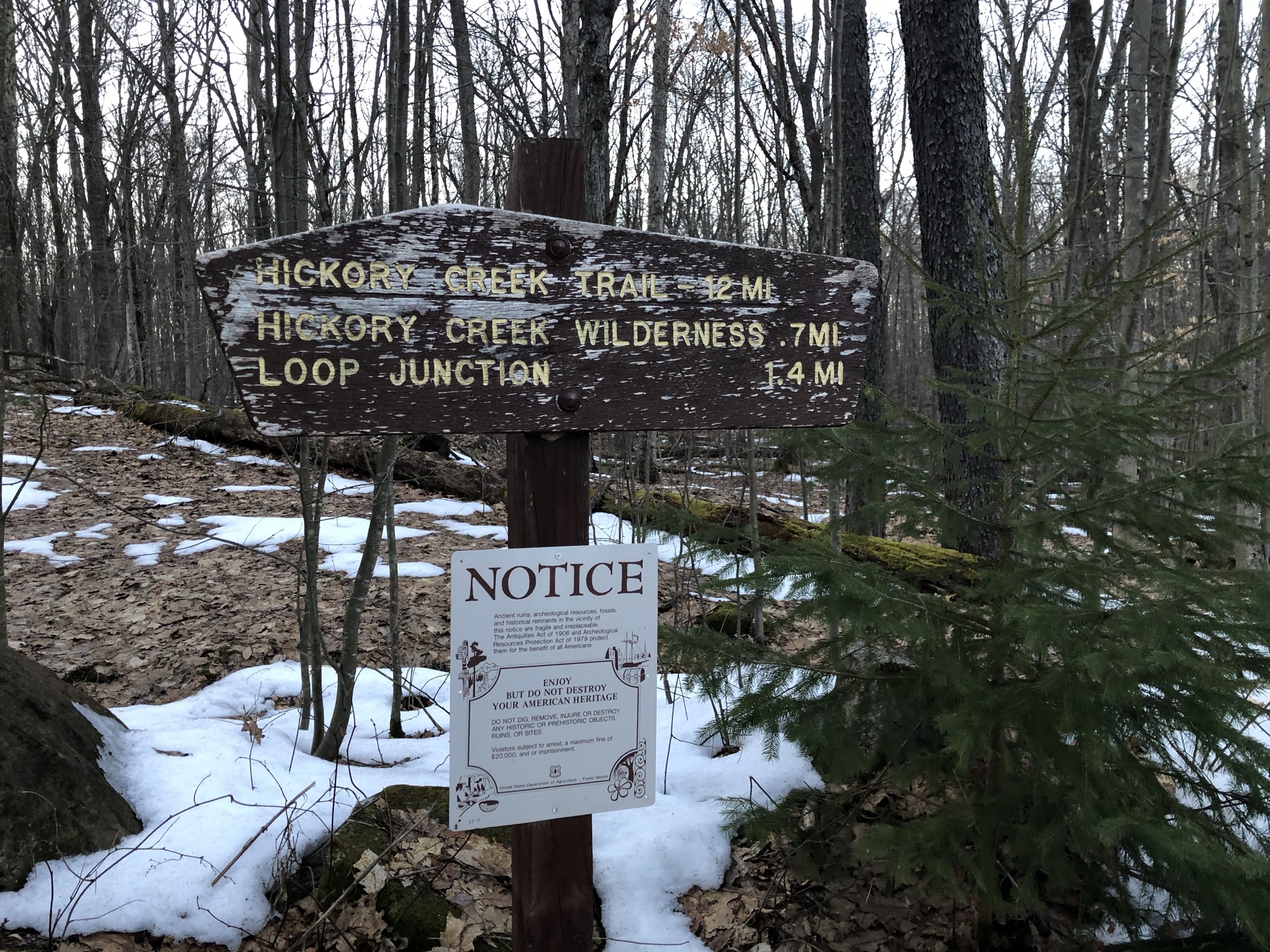
First, the negative observations: How did I come here without expecting snow on the ground? Pittsburgh has been so pleasant lately that I made the rookie mistake of coming unprepared for COLD nights. Distances are long here, and the trail is hard to find in March, when all of last year's fallen leaves are equally matted by the melted snow. Because it's a wilderness area, blazes tend to be faded and infrequent--though someone has made an inconsistent attempt to remedy that. And dude! It's almost a mile and a half from the parking lot to the loop trail! That mile and a half feels right long when you’re limping back to your car with 40 pounds digging into your shoulders.

I had to hustle from work to get the kids after school and drop them with their grandma in Franklin, which meant arriving at the trailhead right at 5:00pm. That gave me 1.5 hours of daylight to find a campsite and put up camp. When I finally got to the loop, I cut left for the southerly half because in addition to having a loud neighbor, the northerly half has very little water. Unable to find the campsite on the first nameless little stream, I went uphill from it a few hundred yards and made a makeshift campsite in the trees. Only the next day did I hike past the campsite on that stream, and it was a beautiful spot! It sat in a broad, wooded valley on the other side of the stream. Maybe I'll come back some day just to camp there.

The night was so cold that in the morning I considered turning back, tail tucked, and enjoying the quiet house at home--with the wife and kids away. But then I recalled that Hickory Creek had humbled me before, and I was too proud to let it happen again. When my friend and I were lost in the trackless (but lovely and loud) northern areas of the wilderness, we kept looking for the place where Jack's Run flowed into East Hickory Creek. We thought we might follow Jack's Run up to the main trail. We never found it, so my goal for this day was to make it to the end of Jack's Run and either spend another frigid night there or else hike back to my car, finishing the loop. Lovely hemlocks like this one urged me forward.

There are some magnificent trees at Hickory Creek. Broad and very tall. There are also frequent blowdowns that can cause you to lose the trail. I don't know why the ANF gets so many blowdowns. Climate change, of course, but I think the plateau known as "The Big Level," where the forest is located, has always been prone to them. My guess is that the winds come whipping in off the plains of the Midwest and cannot resist the temptation to wreak a little havoc on those grand trees. I've read that the most southerly areas of the wilderness are almost impassable because a windstorm that went through there in the 1985--not the tornado that took down the Kinzua Bridge, which occurred in 2003–see the correction by a faithful reader, below. Tornados are rare in these parts, but high winds apparently are not.
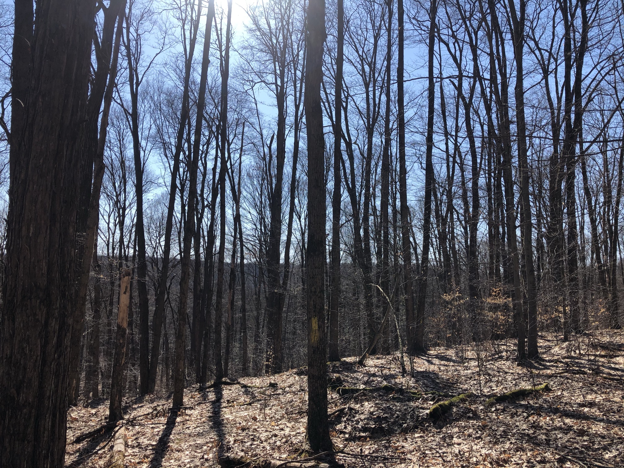
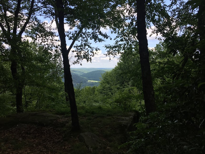
Vistas are few, but in March, when the trees are still not in leaf, there are some broad views. There's only one trail through the wilderness, barring the abandoned trails where my friend and I got lost in April of 2017. It's a 12-mile loop that Jeff Mitchell (hiking guru of PA) says can be done as a day hike. That's about six hours for the whole loop. Then you've got to add in the half hour each way just to get in from the parking lot. That's a 7-hour hike. If you stop to take pictures and rest breaks, it might amount to an 8-hour day--just like you put in at the office. BUT! But if you're not familiar with the trail, you've got to add all the anxious moments of just trying to find the damned thing. Honestly, I bet it would accumulate into 45 minutes or an hour altogether. Okay, maybe half an hour...

It's usually not too hard to find, now that someone has re-blazed parts of it. If you lose it, just look for the most trammeled route with the fewest small plants poking up through the earth. On the Hickory Creek Trail, you'll usually see an old yellow blaze sooner or later if you stand still or move forward slowly, like trying to approach a deer. They're shy, elusive, those blazes. This little body of water is the second full sized brook that you come across on the southerly route, known as Coon Run. The trail follows it for a stretch, and this was my favorite portion of the hike. Nice campsites can be found along the stream as well as these small meadows--a little reminiscent of Dolly Sods.

But let's not compare Hickory Creek to Dolly Sods! My heart couldn't take it. I love the Allegheny National Forest. It's one of my life's sacred places. But it does not begin to compare to the Monongahela National Forest of West Virginia--where the Dolly Sods Wilderness is located. I'll admit that a part of me wanted to do the whole loop at Hickory Creek precisely because I wanted to contrast and compare the two wildernesses. We can do that briefly. Dolly Sods has fantastic broad vistas, very well marked and established trails, and a really terrific variety of terrains. It's also vast, with 17,776 acres. At 8,663 acres, Hickory Creek is a little less than half the size. It has beautiful, tall trees--whereas the trees at the Sods are twisted by the winds and dwarflike. Hickory Creek has a less diverse landscape; it's mainly northern hardwoods forest with a lot of beautiful hemlocks thrown in. The Sods can get pretty crowded with day trippers from DC, and Pittsburgh, and Columbus. But in more than 24 hours at Hickory Creek (25 to be precise), I saw only one other person on the only trail in the place.

Yes, let's talk about that person, shall we? Just as I came upon the fabled Jack's Run, El Dorado of the Allegheny--the stream that I searched for so diligently four years ago--I heard a hoarse barking on the trail behind me. At first I wondered if there was a coyote barking at me, if indeed coyotes do such things. But then, galloping up behind me at an impressive pace came a 60-something fellow with his two dogs off the leash. The barking dog was a Dachshund--which didn't sink in till later. I had taken off my pack at the campsite right on the stream to let him and his dogs pass me by. I greeted him and got a barely-detectable nod in return. But when he saw my enormous backpack he said, "There's people camping out here already?" I said that I was, and he hurried on his way, crossing the stream as if he walked on water--a stream where it would soon take me several minutes to find a dry crossing--and disappearing into the woods. As he crossed over I called to him to ask how long it would take a person to get to the parking lot, but he was long gone.

I think if I had it to redo, I might have subjected myself to another cold night there along Jack's Run, possibly colder than the night before, since the day was a lot colder. Maybe go to the place where the trail leaves Jack's Run, set up camp in the afternoon and spend a pleasant day reading by a campfire. But in my great rush to get out of the house, I forgot to pack coffee, which redeems the cold, and the previous night had been one of the coldest I'd ever spent in a tent. So I decided to push on. If a guy in his 60s with no water bottle can make a day hike of it, not to mention a Dachshund, then I'd have no trouble.

Jeff Mitchell claims that Jack's Run is the most scenic spot along the trail. It was pretty, with lots of hemlocks and shaded areas. But in the March chill, I preferred the open sunny meadows along Coon Run. Also, the trail crosses Jack's Run in two places. There are no bridges in the wilderness, and all the snowmelt had swollen the water levels, so I did get a little wet.

I took lots of photos of campsites so that I could decide later which ones would be worth coming back for. Also, I was still kind of deciding whether I wanted to set up camp here or push on. I had officially decided to finish the loop that same day, but I had time--if not the right sleeping bag--and the perfect campsite could have convinced me. Much like the abandoned trails where my friend and I got lost, the one along Jack's Run used to be a railroad. You can see the contours of the rotting ties beneath your feet, and it can be pretty swampy.

This is actually the campsite where the trail first joins Jack's Run if your traveling the loop in a clockwise direction--the place where I first encountered the Dachshund. Okay, the barefoot little dog with the tiny legs? When I saw it barking at me, my first thought was, "puny little creature thinks it's a dog." But when I got to thinking about it, that little dog was running 15 miles and keeping up just fine with the Caucasian Kenyan of the north country. I was starting to feel a little worn down. My pack weighed heavily on my shoulders, putting stress on my left clavicle, which I broke when I was 13 playing football on an icy parking lot. It's never done that before, but it started to hurt pretty bad. My pack was beginning to feel like a dead man on my back. My feet hurt, my neck, my shoulders, my legs. They say to expect to go six miles a day with your pack, and I had only done four miles so far that day, but I knew that there was no water and no campsites past this point. I should have set up camp and faced the cold as a punishment for my ill-preparedness. But no. No, I pushed on. After finally finding the unmarked trail after the second stream crossing, I began a long, slow slog uphill that lasted for much of the rest of the hike--another six miles. I pushed on through picturesque-enough woods, losing the trail very frequently, with increasing slowness and weariness. The northerly half of the loop is by far the less appealing, but I told myself that if the sun set before I reached the connector trail back to the parking lot, I could always camp somewhere without water. At this point, I was becoming a little too anxious to take photos.

With forty pounds on my back, it took me 4 hours to walk the last six miles--the longest six miles of my life! No water, mostly uphill, constantly on the lookout for this one and only signpost that exists in the wilderness. Even though it's the very thing you're looking for, it comes as such a surprise when you see it at long, long last. Parking lot, that way! But don't get too excited. There's still another mile and a half to go.

Occasionally in the patches of snow on the trail, I would see the footprints of that mighty little Dachshund, and it would bring me just a tinge of shame.

So...I've been backpacking for many years, and it's true that I've never done 10 miles in a single day with a big backpack. So I could forgive myself for doing it a little slowly--just a little faster than one mile per hour. But it was a little alarming, too. I'm planning a 98-mile trek all the way across the ANF this summer, and I wonder if I'm as able as I thought I was... I mean, c'mon, a Dachshund? I really wish I could have asked that trail runner how long it took him to do those 15-miles. He clearly knew the trail well and did the trek frequently. The kiosk at the trailhead advertises maps and a trail register, but it's just bluffing. There's neither. C'mon, this is the Allegheny National Forest, not Yellowstone.

Five cars in the parking lot. When I arrived on Friday night, I was sure the lot would be crowded, but there was only that truck, on the right, and me. So, to recap: Hickory Creek along the southern half of the loop is scenic, silent, and uncrowded with lots of nice places to camp and plenty of water. But you'll spend a lot of time looking for the trail. If you don't need to do the whole loop, stick to the southern half. The northern half is nice but there is the noisy neighbor shooting his guns and possibly bombs (sounds like it) as well as the fact that there's not much water and it's less scenic. I'm thinking about going back and sticking to the southern half...


